


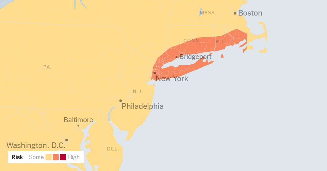
The punishing heat wave that made most of last week nearly unbearable across New York is finally over, but a new week is bringing a new weather danger: the potential for torrential rain and flash flooding.
The National Weather Service warned that between late Sunday and early Tuesday, multiple rounds of thunderstorms could unleash enough rain to cause significant flash flooding across the region.
The greatest areas of concern were from northern and coastal New Jersey through southeast New York, including the New York City area, Long Island, southern Connecticut, southern Rhode Island and into parts of southeast Massachusetts.
Storms in this corridor may repeatedly move over the same places, a pattern known as “training,” which can quickly lead to high rainfall. Widespread amounts, of about three to six inches of rain, are possible, with isolated areas potentially seeing eight inches of rainfall or more, the service said.
Farther west, from parts of Pennsylvania toward the Washington, D.C. area, storms were also expected but they were likely to be more scattered. Forecasters said there was less uncertainty in this region, regarding where the heaviest rain would fall and how long individual storms would last. Despite this, some storms could still produce very intense downpours, with rainfall rates reaching around two inches per hour.
A flood watch was in effect through Tuesday morning across a large area of the Northeast and the Mid-Atlantic, including the New York City region.
On Sunday night, as forecasters watched the weather system’s ingredients come together west of New York, they were still uncertain where, exactly, the worst of the rain would fall.
Parts of Pennsylvania and Ohio had already received several inches of rain as of early Monday, and some flooding was occurring. The National Weather Service office in State College, Pa., said that some of the heaviest rainfall totals reached around five inches, particularly east of Harrisburg, where 5.32 inches was recorded in Hummelstown.
In New York, despite some storms on Sunday, forecasters said the heaviest rain was expected by Monday morning and would last throughout the day. New York City, Long Island and suburbs just to the north and east could record up to two inches of rain per hour.
“Please — take this weather seriously,” Mayor Zohran Mamdani of New York said on Sunday. He warned that travel could be treacherous, especially around the morning commute hours.
The governor, Kathy Hochul, said state agencies had been mobilized to respond to any flooding.
When significant rain falls very quickly, areas such as basements, subways and low-lying streets can flood within minutes.
On Monday, many towns across the New York region were still cleaning up after storms on Saturday night dampened many Fourth of July celebrations.
Tens of thousands homes and businesses across New York, New Jersey, Connecticut and Pennsylvania were still without power after strong winds brought down power lines and tree limbs.
The Weather Service said storms were expected to continue into Tuesday and early Wednesday across parts of the Mid-Atlantic, although they were expected to be isolated and weaker. Additional showers and thunderstorms were also possible over parts of eastern Massachusetts and Rhode Island, though the impacts were expected to be more limited and less widespread.
