


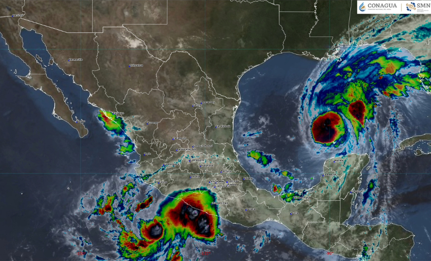
Isaias, the first Atlantic hurricane of the 2026 season, is whipping past the Yucatán Peninsula on its approach to the U.S. Gulf Coast, while Tropical Storm Simon is poised to become a hurricane in the Pacific by Thursday night.
Hurricane Isaias, located 280 km northwest of Progreso in northwestern Yucatán is bringing heavy and intense rainfall to eastern and southeastern Mexico.
Actualización del #Huracán #Isaias sobre el #GolfoDeMéxico. Mantiene su desplazamiento hacia el este-noreste. Detalles ⬇️
— CONAGUA Clima (@conagua_clima) October 8, 2026
After rapidly intensifying over the warm waters of the Gulf of Mexico to the west of the peninsula, “Isaias” is heading on a trajectory directly towards the southern United States.
Upgraded to a hurricane on Wednesday night, Isaias — the ninth named storm of the season — is the latest first hurricane in the 60-year modern era.
The previous record-long wait for the first hurricane in the satellite era was until Sept. 11 (in both 2013 and 2002), although the pre-satellite era record dates to 1905, when the year’s first Atlantic hurricane formed on Oct. 8.
Isaias could become a Category 3 hurricane before it makes landfall anywhere from Mississippi to Florida on Friday evening.
Meanwhile, the storm’s intense circulation will dump heavy rains (from 80 to 150 mm) along Mexico’s Gulf coast, drenching Veracruz, Tabasco, Campeche and Yucatán.
Additionally, cloud bands will cause significant rainfall along the coastal strip of Tamaulipas and in northern Quintana Roo.
Sustained winds of up to 40 km/h with gusts of 50 to 70 km/h are expected in Veracruz, while on the coasts of Tamaulipas, Tabasco, Campeche and Yucatán gusts will range between 40 to 60 km/h.
In the Pacific, Simon is forecast to become a hurricane later today as it approaches Mexico’s west-central coast on Saturday.
A Hurricane Watch is in effect from Manzanillo, Colima, to Punta San Telmo, Michoacán. The U.S. National Hurricane Center warned of life-threatening wind and storm surge impacts as it becomes a major hurricane.
9 am CST – Tropical Storm #Simon is expected to become a hurricane later today and a very dangerous category 4 hurricane before it reaches the coast of Mexico. A Hurricane Watch has been issued for a portion of west-central Mexico. Visit for updates.
— NHC Pacific (@NHC_Pacific) October 8, 2026
Located 305 km south-southwest of Lázaro Cárdenas, Michoacán, Simon is moving west at about 11 km/h and is forecast to turn northward and approach the southwestern coast of Mexico on Saturday.
Heavy to torrential rains are forecast for areas of Guerrero, Oaxaca and Chiapas today, while winds with gusts of 50 to 70 km/h are expected along the coasts of Michoacán and Guerrero.
With reports from USA Today, Meteored, El Financiero and CNN en Español
